A Brief History of Glaciers in Latvia
The formation of Latvia’s glacial relief during the last glaciation mainly began when the territory of Latvia was completely covered by ice masses approximately 20,000–22,000 years ago. As in present-day Greenland and Antarctica, the ice was not stationary but moved at a speed of several hundred metres per year or even faster. In places where large depressions oriented in the direction of glacier flow lay beneath the glacier, the ice flow was fastest.
Scientists in Latvia have identified ice streams [parts of a glacier that flowed faster than the surrounding ice], lobes [broad protrusions at the edge of a glacier], and tongues [narrow, elongated glacial protrusions]. There were only three ice streams – the Baltic, Riga, and Peipsi ice streams. There were, however, many more ice lobes and tongues. As they advanced repeatedly, Latvia’s characteristic present-day relief was formed. The largest ice lobes advanced into the lowlands, and these were the Kursa, Usma, Zemgale, Burtnieks, Middle Gauja, and Lubāns lobes.
When the climate became slightly warmer, the final stage of the Ice Age began, during which Latvia’s landscape changed very rapidly. Fifteen thousand years ago, Latvia’s largest uplands rose like islands in the surrounding realm of ice, where glaciers advanced and retreated rapidly, leaving behind proglacial lakes that covered a large part of Latvia’s lowlands.
As these extensive proglacial lakes drained, only small lakes remained in some parts of Latvia’s present-day landscape. The Ice Age ended 11,700 years ago, when the interglacial period, or the Holocene, began.
A New Perspective on Glacial Activity in Latvia
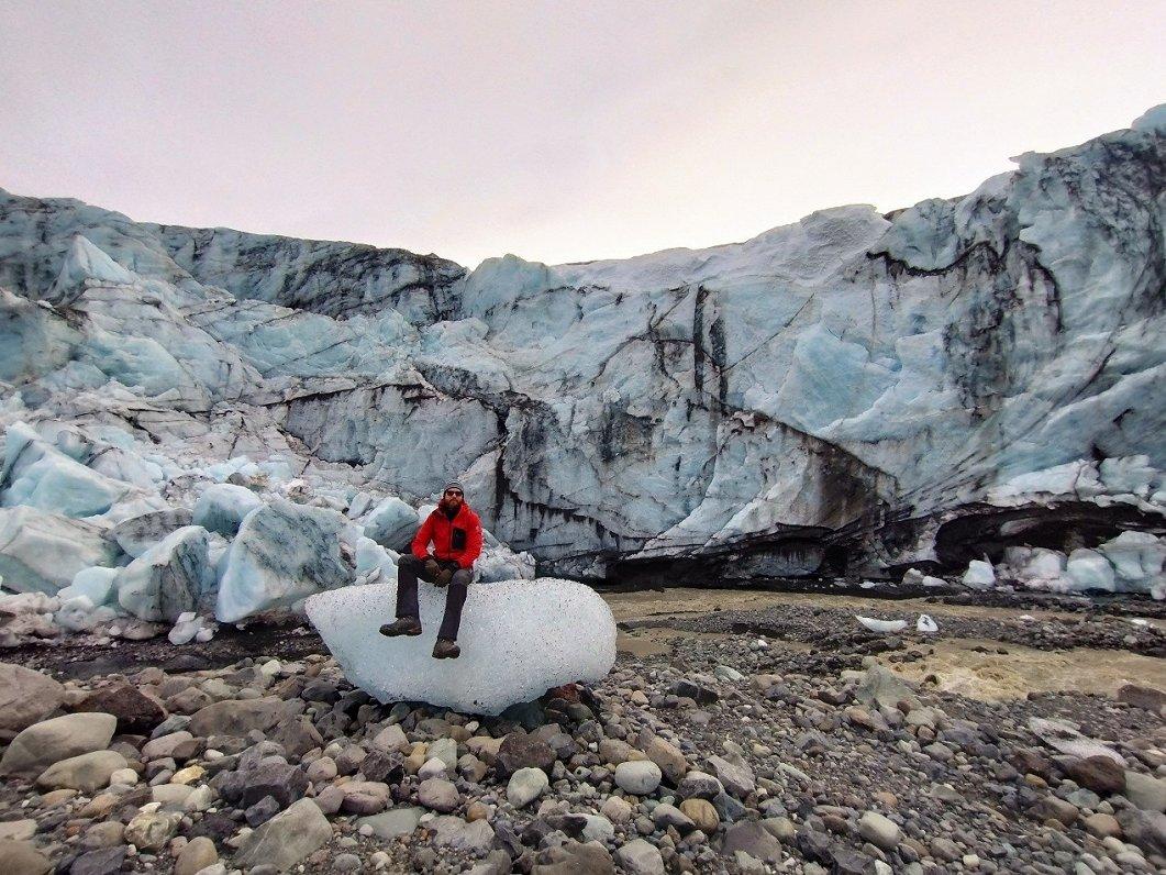
University of Latvia researchers have found that, during the disappearance, or deglaciation, of the Scandinavian Ice Sheet, ice surges occurred repeatedly, mainly in Latvia’s lowlands. Such glacier behaviour is also observed today, particularly in Svalbard and Iceland, for example at the Múlajökull and Eyjabakkajökull outlet glaciers, where glaciers advance rapidly after a prolonged “quiescent period”, often within just a few months or years.
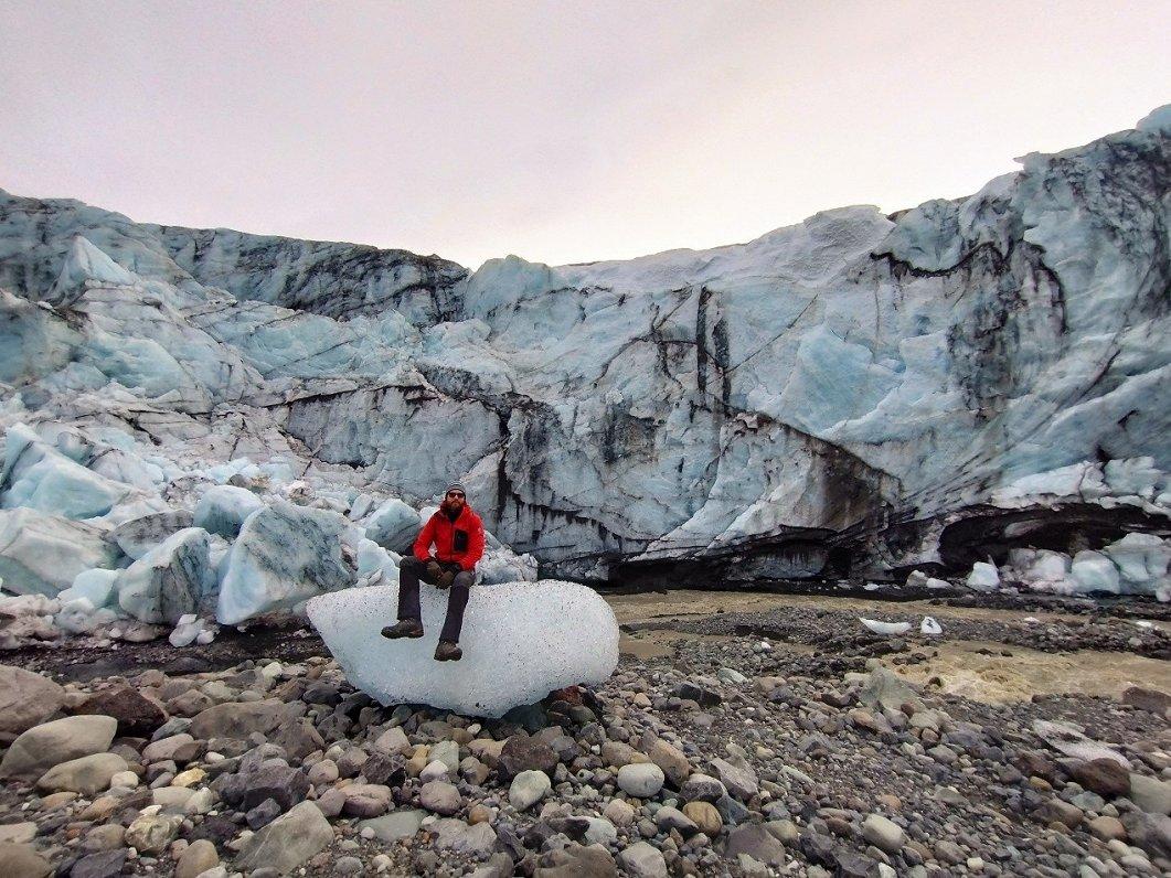
The landforms observed in terrain models and in the area from which the glacier has retreated – crevasse-fill ridges – are unequivocal evidence of rapid ice surges, with the ice sliding over a layer of water at its base or over a water-saturated mass of subglacial sediments.
University of Latvia scientists first encountered such landforms near the Eyjabakkajökull outlet glacier in Iceland. It turned out that more than 30,000 crevasse-fill ridges are also found in Latvia – mainly in the Kursa and Eastern Latvia lowlands.
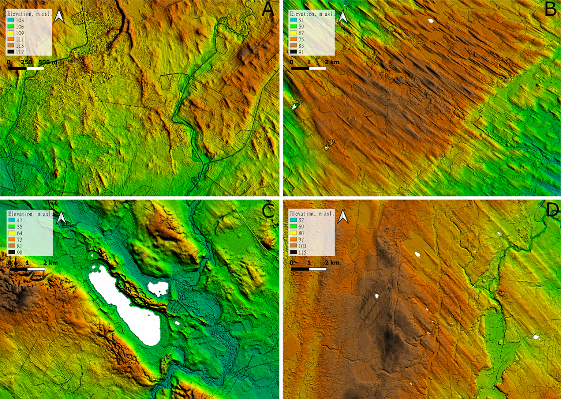
Often only a few tens of metres wide and less than a metre high, yet well preserved in the relief, the ridges are clear evidence of rapid ice flow, crevassing, and the glacier coming to a halt across a wide area. Until now, such dynamic glacial activity in the Baltic region was not known.
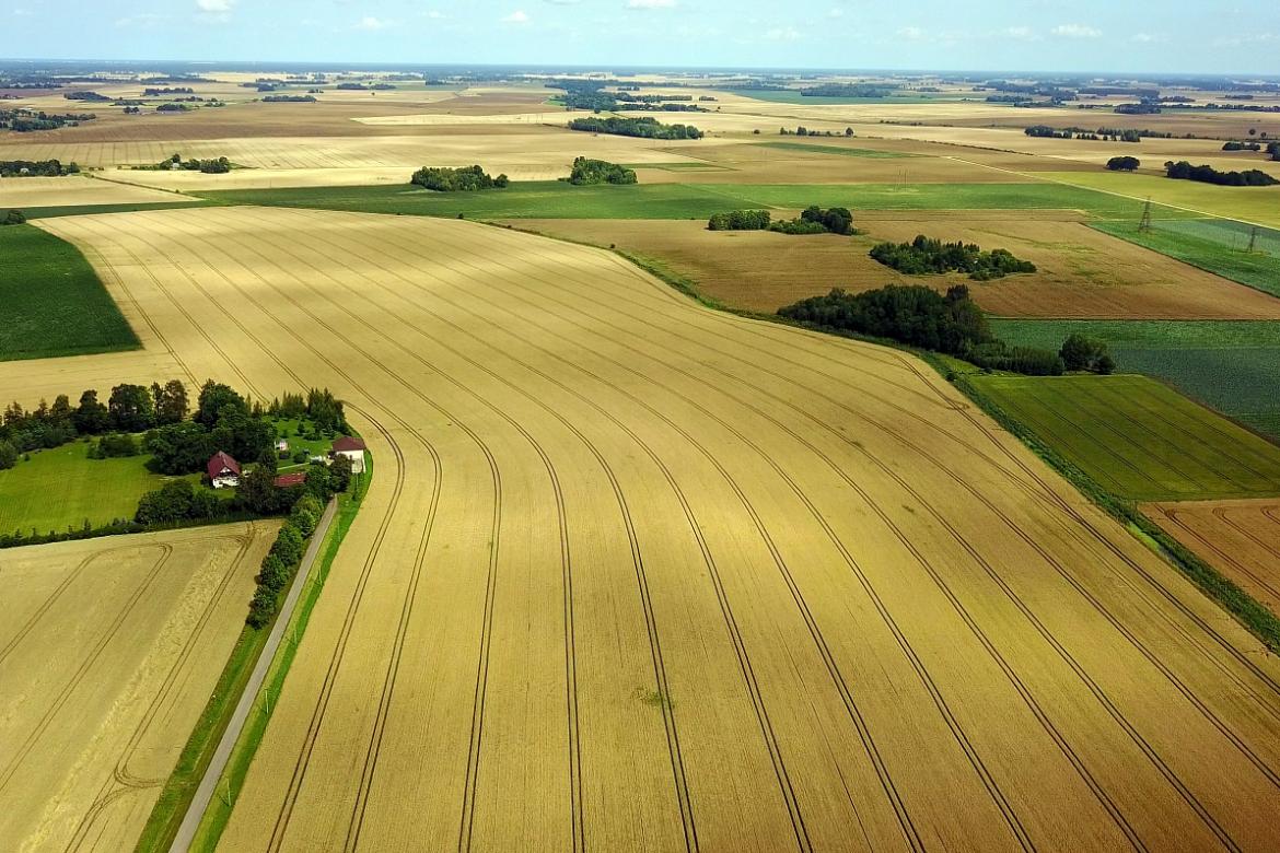
Although the study of glacial landforms in Latvia and the Baltic region has a history spanning more than a hundred years, only now can geomorphologists view Latvia “from above” using terrain models. This makes it possible to imagine what this territory looked like approximately 20,000–22,000 years ago, when it was covered by the Scandinavian, or Fennoscandian, Ice Sheet, just as Greenland today is covered by the largest ice sheet in the Northern Hemisphere.
Why Are Glacial Landforms Important?
Scientists use crevasse-fill ridges and other glacial landforms to draw conclusions about the speed and direction of glacier movement, glacier retreat, the amount of glacial meltwater, and the way it drained. They also use them to study glacier dynamics, crevassing, thermal conditions, and many other aspects. From an applied perspective, glacial landforms are a valuable part of Latvia’s shallow subsurface, as they contain mineral resources widely used in construction, such as sand, gravel, and clay.
On the other hand, glacial landforms and the rugged terrain they have created are not only historical evidence of glacial activity, but also the foundation and a valuable part of Latvia’s landscape, which must be studied, used responsibly, and protected. To understand how these landforms developed and what they reveal about Latvia’s ancient glaciers, geomorphologists and Quaternary geologists use increasingly precise research methods.
Mapping Landforms
The open airborne laser scanning data of the Latvian Geospatial Information Agency have made it possible to view Latvia’s relief from a bird’s-eye perspective, and with unprecedented precision. To conduct scientific research, glacial landforms must not only be identified but also mapped, and their dimensions, spatial arrangement, structure, and formation mechanisms must be analysed. This remains a fairly labour-intensive manual task involving both scientists and students from the University of Latvia’s Faculty of Science and Technology.
The database of Latvia’s glacial landforms created by University of Latvia scientists represents glacigenic, glaciotectonic, and glacioaquatic landforms. These landforms were created both from sediments deposited by the glacier itself, or till, and from deposits laid down in glacial meltwater streams and lakes.
Landforms are highly diverse in their shape, structure, and formation environment, and each group of landforms provides evidence of specific conditions within, above, beneath, or alongside the glacier that formed them.
Today, machine learning capabilities are also used in landform mapping. University of Latvia Faculty of Science and Technology doctoral students Edijs Breijers and Hugo Huberts Puriņš are currently working on model training and workflow development to automate the recognition and digitisation of landforms. The tools developed will be useful for reconstructing glacial relief and dynamics across a much wider area of the former Scandinavian Ice Sheet.
Under the leadership of Associate Professor Kristaps Lamsters and Professor Normunds Stivriņš from the Department of Geology at the University of Latvia’s Faculty of Science and Technology, a project of the Latvian Council of Science’s Fundamental and Applied Research Programme (FLPP) is being implemented, in which all glacial landforms in Latvia are being mapped and analysed, and the chronology of glacial activity is being reconstructed. Mapping the landforms and creating the database is the first step, but the main objective is to reconstruct the ice-flow dynamics of the southeastern sector of the Scandinavian Ice Sheet and the course of deglaciation, or retreat.
Scientific collaboration is highly important in landform research. The last ice sheet covered all the countries around the Baltic Sea and an even larger area, so data obtained in different countries must be combined in order to reconstruct glacier dynamics and palaeogeography. University of Latvia scientists are currently cooperating with colleagues from Germany, Poland, Lithuania, Estonia, and Finland to analyse eskers [ridges of sand and gravel formed by glacial meltwater] and reconstruct the course of glacier retreat based on the characteristics of glacial meltwater drainage.
The data obtained so far by Latvian scientists represent a highly significant step towards creating detailed reconstructions of the entire Scandinavian Ice Sheet.
Glacial Landforms in Latvia
We certainly encounter glacial landforms too – if not in our everyday lives, then while spending time in nature. In everyday language, we use terms for landforms such as mountains, ridges, and hills, as well as various place names (oronyms), such as the Blue Hills, Gravel Hills, Sun Hills, Tower Hills, Cuckoo Hills, and many others.
It may seem that Latvia has no shortage of mountains, although from a geomorphological perspective, unfortunately, there are none here – instead, there are hills, ridges, embankments, and massifs of various sizes and shapes.
Glacial landforms are among the most widespread landforms in both Latvia’s lowlands and uplands. Most of them formed beneath the glacier. Examples include subglacial streamlined landforms – flutings, drumlins, and mega-scale glacial lineations. Across most of Latvia’s lowlands, these landforms form fields of radially arranged loaf-shaped or cigar-shaped features, such as the Burtnieks, Vadakste, Zemgale, Iecava, and Madliena drumlin fields. By studying the shape and spatial arrangement of these landforms, researchers have determined the direction and speed of glacier flow in Latvia.
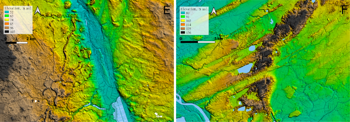
By contrast, crevasse-fill ridges, ribbed moraines, and end moraines extend transversely or obliquely to the former direction of glacier flow. The latter form highly prominent ridges and ramparts in the relief, such as the Madona–Trepe Ridge and the Linkuva end moraine. Subglacial landforms often have no distinct orientation. These are hummocky landforms found mainly in uplands – moraine hills, primary massif hills, flat-topped hills, dome-shaped hills, and ring-shaped hills.
The most widespread landforms in Latvia formed from glacial meltwater deposits are eskers, kames, kame terraces, outwash plains, and glaciofluvial deltas. Landforms created by glacial meltwater erosion, in turn, include tunnel valleys, various types of glacial meltwater channels, and drainage valleys. In some places, these landforms are occupied by rivers in the present-day relief, while elsewhere deep and wide valleys are dry or contain relatively small watercourses.
Among the most scenic landforms created by glacial meltwater deposits, particularly in the lowlands, are eskers. In everyday language, they are often called kangari, for example, the Ogre, Lielie, and Mazie Kangari.
The most widespread landforms in Latvia formed from glacial meltwater deposits are eskers, kames, kame terraces, outwash plains, and glaciofluvial deltas. Landforms created by glacial meltwater erosion, in turn, include tunnel valleys, various types of glacial meltwater channels, and drainage valleys. In some places, these landforms are now occupied by rivers, while elsewhere deep and wide valleys are dry or contain relatively small watercourses.
Among the most scenic landforms created by glacial meltwater deposits, particularly in the lowlands, are eskers. In everyday language, they are often called kangari, for example, the Ogre Kangari, Lielie Kangari, and Mazie Kangari.
Nearly five thousand eskers are found in Latvia. Most of them are several hundred metres or even kilometres long, narrow, often winding ramparts, and flat or hilly ridges whose crests usually extend approximately parallel to the direction of glacier movement. Eskers often consist of gravel and sand deposits suitable for construction, which is why some have been quarried away, while nature parks have been established in others, and they are protected mainly because of their biodiversity and rare plant species.
The publication of the landform database created by University of Latvia scientists will require a little more time, but geochronological data from the last Ice Age, or sediment dates, for the whole of Latvia are currently freely available in the open-access repository “Zenodo”: https://zenodo.org/records/21035962
The article was developed within the Latvian Council of Science’s Fundamental and Applied Research Programme project “Reconstruction of Ice-Flow Dynamics and the Course of Deglaciation of the Southeastern Sector of the Scandinavian Ice Sheet in Latvia” (No. lzp-2024/1-0193).